Cary Map of the World on Mercator Projection, John Cary, 1754 – 1835, English cartographer.1801, Cary Map of the World on Mercator Projection, John Cary, 1754 – 1835, English cartographerProjection, Map
world map, semi-detailed mercator projection on gray background - mercator projection stock illustrationsWorld Map, Semi-Detailed Mercator Projection on Gray BackgroundWorld Map, Map, Projection
Mitchell Map of the World on Mercator Projection.1866, Mitchell Map of the World on Mercator Projection
S map of the world on Mercator's projection. The British Empire shown in red.A 1930's map of the world on Mercator's projectionMap, 1930-1939, Projection
Sky chart of the north and south starry sky in Mercator projection Sterre kaert of hemels pleyn, waer door men kan wete hoe laet dat het is over de...Sky chart of the north and south starry sky in Mercator projection Sterre kaert of hemels pleyn
Baur and Bromme Map of the World on Mercator Projection.1870, Baur and Bromme Map of the World on Mercator ProjectionMap
Vaugondy Map of the World on Mercator Projection.1784, Vaugondy Map of the World on Mercator ProjectionMap
Belgian Defence Minister Pieter De Crem and Institut Geographique National General Administrator Ingrid Vanden Berghe attend the presentation of the...Belgian Defence Minister Pieter De CremProjection
Johnson Map of the World on Mercator Projection.1865, Johnson Map of the World on Mercator Projection
Mitchell Map of the World on Mercator Projection.1864, Mitchell Map of the World on Mercator Projection
World map showing emigration routes and British Empire, This geographical and physical map of the world on Mercator's projection shows British...World map showing emigration routes and British EmpireMap, Emigration and Immigration
Map of the world by Edward Stanford Limited marked with the paths of totality for the Saros cycle of eclipses from 1927-2164. The time and location...�Diagram Illustrating the Saros Cycle of Eclipses�, 1927.Bicycle
Detail of a map of the world on the Mercator projection by the Flemish cartographer Jodocus Hondius , showing the region around the South China Sea....The South China Sea, 1608.Sea, Map, South China Sea
Map - The World on Mercator's Projection', 1902. From The Living Races of Mankind, Vol. I. [Hutchinson & Co, London, 1902]. Artist Unknown.Map Of The World On MercatorS ProjectionMap, Ethnicity
antique map of the world - mercator projection stock pictures, royalty-free photos & imagesAntique map of the worldMap, Antique
vintage world map - mercator projection stock pictures, royalty-free photos & imagesVintage world mapMap
graphic of the world with converging lines on horizon - mercator projection stock illustrationsGraphic of the world with converging lines on horizon
world map displaying time zones - mercator projection stock illustrationsWorld map displaying time zones
Mercator projection, Invented in 1569 by the Dutch geographer Gerard Mercator, the Mercator projection compensates for the east_west distortion with...Mercator projection
An 1826 Mercator projection map of the World shows all the continents and oceans. It includes such entries as New Holland, United Provinces, Southern...Map of the WorldWorld Map, Map, Engraving
Statue of Gerardus Mercator, Flemish cartographer, remembered for the Mercator projection world map, which is named after him, in front of the Church...Statue of Gerardus Mercator, Flemish cartographer, remembered for the Mercator projection world map, which is named after him, in front of the Church of Our Lady at Rupelmonde, Belgium
Statue of Gerardus Mercator, Flemish cartographer, remembered for the Mercator projection world map, which is named after him, in front of the Church...Statue of Gerardus Mercator, Flemish cartographer, remembered for the Mercator projection world map, which is named after him, in front of the Church of Our Lady at Rupelmonde, Belgium
Entitled "A General Map of the World, or Terraqueouis Globe with all the New Discoveries and Marginal Delineations, Containing the Most Interesting...Double hemisphere wall map of the world by Samuel Dunn
Circa 1570, Gerardus Mercator . Flemish geographer and mapmaker . To aid navigators, in 1569 he introduced the map projection that bears his name and...Gerardus MercatorGerardus Mercator
Map of the world on the Mercator projection, exhibiting the American continent as its center, 1900. From the New York Public Library. .Map Of The WorldMap
world map with graticules (mercator projection) - mercator projection stock illustrationsWorld map with graticules (Mercator projection)World Map, Map, The Americas
Map of Magellan's round the world voyage, 1519-1521. A Portuguese-born navigator sponsored by Spain, Ferdinand Magellan led the expedition that made...Map of Magellan's round the world voyage, 1519-1521.Ferdinand Magellan, Magellan Satellite, 16th Century
Chart of the world on Mercator's Projection, with the most recent discoveries.World MapWorld Map, 18th Century
The World on Mercator's Projection by James Wyld Geographer to the King 1:45 000.The World On Mercator'S Projection
Man checks the "Equal Earth" map projection on a screen in Shanghai, China, Sunday, Sept. 6, 2026. The United Nations General Assembly recently...China "Equal Earth" map
Man checks the "Equal Earth" map projection on a screen in Shanghai, China, Sunday, Sept. 6, 2026. The United Nations General Assembly recently...China "Equal Earth" map
Man checks the "Equal Earth" map projection on a screen in Shanghai, China, Sunday, Sept. 6, 2026. The United Nations General Assembly recently...China "Equal Earth" map
An infographic on the "United Nationsâ efforts to promote maps that more accurately represent Africa" created in Ankara, Turkiye on September 8, 2026.United Nations to promote maps that more accurately represent Africa
Infographic explaining different map projections and the advantages and limits of three projections: the Mercator, the Gall-Peters and the Equal...UN-POLITICS-GEOGRAPHY-AFRICA-DIPLOMACY-INFOGRAPHICS-MAP-MERCATOR-GALL-PETERS-EQUAL EARTH-PROJECTION
map from old french atlas: mercator projection - mercator projection stock illustrationsMap from old French Atlas: Mercator ProjectionMap, Gerardus Mercator, World Map
This is a 120º panorama of the Northern Lights across the northern sky on February 26, 2025 during a Kp3-level display. This shows some fine ray...Aurora Panorama with Northern Stars (February 26, 2025)
The text at the top of this world map by Abraham Ortelius reads: Typus Orbis Terrarum . The map dates to 1570 and is the first map of the world to...Ortelius's Map of World
This geographical and historical outline map shows the world according to Mercator's Projection.Map of World Mercator's Projection
An infographic titled "World maps drawn with different projections can shape the perception of societies" created in Ankara, Turkiye on September 8,...World maps drawn with different projections can shape the perception of societies
Nightscape scene under a twilight 'blue-hour' sky, on the Red Rock Canyon Road in Waterton Lakes National Park, Alberta, looking west toward the...Mountain Flowers with Twilight MoonMountain, Outer Space, Night
old chromolithograph map of commercial chart of the world on mercator's projection - mercator projection stock pictures, royalty-free photos & imagesOld chromolithograph map of commercial chart of the World on Mercator's projectionMap, Africa, World Map
old chromolithograph map of commercial chart of the world on mercator's projection - mercator projection stock pictures, royalty-free photos & imagesOld chromolithograph map of commercial chart of the World on Mercator's projectionWorld Map, Map, Africa
Gerardus Mercator, 1512-1594. Flemish Cartographer. The Mercator Projection Is Named After Him. From Crabb's Historical Dictionary Published 1825.Gerardus MercatorGerardus Mercator, Map
Australia Circa 1760. Mercator Projection. From Atlas De Toutes Les Parties Connues Du Globe Terrestre By Cartographer Rigobert Bonne Published...Australia Circa 1760Australia, Map, Zeeland
Australia Circa 1760. Mercator Projection. From Atlas De Toutes Les Parties Connues Du Globe Terrestre By Cartographer Rigobert Bonne Published...Australia Circa 1760
Illustration depicts Flemish cartographer Gerardus Mercator , with a globe and compass in his hands. He devised a design format for geographic maps,...Portrait Of Gerardus MercatorGerardus Mercator
Chart of the World on Mercator's Projection with the Most Recent Discoveries. 1798 map by cartographer William Faden, engraved by William Palmer....Chart of the World on Mercator's Projection with the Most Recent DiscoveriesGerardus Mercator, 1850-1859
world map with graticules (mercator projection) - mercator projection stock illustrationsWorld map with graticules (Mercator projection)World Map, Map, Longitude
high detail world map mercator projection - mercator projection stock illustrationsHigh Detail World Map Mercator ProjectionWorld Map, River, Globe - Navigational Equipment
Gerardus Mercator was a cartographer, He is remembered for the Mercator projection world map, which is named after him, This proved very useful to...Gerardus Mercator Gerardus Mercator, Map
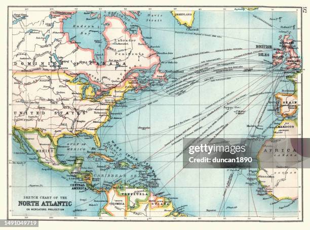
old sketch chart of the north atlantic on mercator projection, shipping routes, europe, north and south america, 1890s, 19th century - mercator projection stock illustrationsOld Sketch chart of the North Atlantic on Mercator projection, Shipping routes, Europe, North and South America, 1890s, 19th CenturyMap, Nautical Chart, Archival
map of the world in mercator projection 1848 - mercator projection stock illustrationsMap of the world in mercator projection 1848World Map, Map, Old-fashioned
world in mercator's projection map 1876 - mercator projection stock illustrationsWorld in mercator's projection map 1876Map, World Map