Development of the British Empire, lithograph, published 1897 - stock illustration
Map of the territorial development of the British Empire from the 17th century to the end of the 19th century. Lithograph, published in 1897.

Get this image in a variety of framing options at Photos.com.
PURCHASE A LICENSE
All Royalty-Free licenses include global use rights, comprehensive protection, simple pricing with volume discounts available
$375.00
USD
Getty ImagesDevelopment Of The British Empire Lithograph Published 1897 High-Res Vector Graphic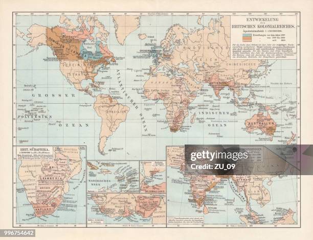 Download premium, authentic Development of the British Empire, lithograph, published 1897 stock illustrations from Getty Images. Explore similar high-resolution stock illustrations in our expansive visual catalogue.Product #:996754642
Download premium, authentic Development of the British Empire, lithograph, published 1897 stock illustrations from Getty Images. Explore similar high-resolution stock illustrations in our expansive visual catalogue.Product #:996754642$375$50
Getty Images
In stockDETAILS
Credit:
Creative #:
996754642
License type:
Collection:
DigitalVision Vectors
Max file size:
8070 x 6195 px (26.90 x 20.65 in) - 300 dpi - 47 MB
Upload date:
Location:
Germany
Release info:
No release required
Categories:
- Map,
- Colonialism,
- World Map,
- Imperialism,
- 17th Century,
- British Empire,
- India,
- UK,
- British Culture,
- 19th Century,
- Colonial Style,
- Europe,
- North America,
- Topographic Map,
- 18th Century,
- Colony - Group of Animals,
- England,
- Africa,
- Asia,
- Australia,
- Blue,
- Brown,
- Capitalism,
- Central America,
- Development,
- Empire,
- English Culture,
- Engraving,
- Germany,
- Growth,
- History,
- Horizontal,
- Illustration,
- Landscape - Scenery,
- Latin America,
- Lithograph,
- Multi Colored,
- South Africa,
- South America,
- The Past,
- Victorian Style,
- White Color,