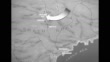
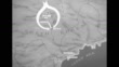
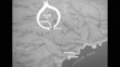
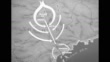
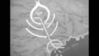
Map shows route taken by US/UN forces escaping encirclement by Chinese troops in the Chosin Reservoir
Animated map of North Korea depicts route taken by US Marines and US Army troops and UN Forces from the Chosin Reservoir to Hungnam, where they were evacuated; arrows from sides represent Chinese People's Liberation Army (Chinese Army) attacks as the combined forces made their way to Hungnam; the breakout began on 12/6/50 and the last UN forces were evacuated on 12/11/50
PURCHASE A LICENSE
Get personalized pricing by telling us when, where, and how you want to use this asset.
DETAILS
Editorial #:
1073311418
Collection:
Sherman Grinberg Library
Date created:
December 09, 1950
Upload date:
License type:
Rights-ready
Release info:
Not released. More information
Clip length:
00:00:31:12
Location:
United States
Mastered to:
QuickTime 10-bit ProRes 422 (HQ) HD 1920x1080 23.98p
Originally shot on:
35mm B/W Neg
Source:
Sherman Grinberg Library
Object name:
sr003262_03_01.mov
- Korean War,
- Map,
- North Korea,
- Chinese Military,
- 1950-1959,
- Animated Feature Film - Genre,
- Archival,
- Army,
- Beginnings,
- Black And White,
- Chinese People's Liberation Army,
- Conflict,
- Crisis,
- Direction,
- Escaping,
- Evacuation,
- Film - Moving Image,
- HD Format,
- Making,
- Military Attack,
- Newsreel,
- Produced Segment,
- Real Time Video,
- Representing,
- Standing Out From The Crowd,
- US Marine Corps,
- US Military,
- USA,
- United Nations,
- Violence,
- War,